CHAPTER 1 PETROLEUM GEOLOGY
| Jurisdiction | United States |
(2001)
PETROLEUM GEOLOGY
Bureau of Economic Geology
Austin, Texas
[Page 1-1]
Introduction
My name is Scott Tinker, and I am the Director of the Texas Bureau of Economic Geology. In that capacity, I serve as the State Geologist of Texas. I am also the Regional Director of the Petroleum Technology Transfer Council and a Professor in the Department of Geological Sciences at The University of Texas at Austin.
I was born into the oil business, as my father was with Shell Oil Company for 39 years, and until January of 2000, my career was in the oil industry. I have worked as an exploration geologist for a consultant named Bob Sneider and for an independent (UPR), and in reservoir characterization at Marathon Oil's Technology Center.
My wife and I left Texas in 1983, and my wife, four kids and I returned to Texas in January 2000 after 15 years in Denver, Colorado. I don't want to hear how nice Colorado is this time of year. It's pretty nice in Austin as well!
I have undergraduate degrees in Geology and Business Administration from Trinity University, an M.S. in Geosciences from the University of Michigan and a Ph.D. in Geosciences from the University of Colorado in Boulder. I completed part of an MBA at the University of Colorado Denver before I decided if I was going to do the Ph.D., I'd better get after it!
Were it not for a very dynamic Professor of Introductory Geology at Trinity University, combined with field trips and cold beer, I would very likely be a lawyer today. Considering the audience, I will say no more on that topic.
Today, I have been asked to discuss Petroleum Geology with you. I will present the discussion in five sections.
• Plate Tectonics and Sedimentary Basins
• Conditions for a Hydrocarbon Reservoir
• The Exploration and Production Business
• Reservoir Characterization
• Technology and the Future of U.S. Energy Supply
[Page 1-2]
Section 1: Plate Tectonics and Sedimentary Basins
Plate tectonics is probably the most important concept developed in geosciences in the last 100 years. Although theories regarding what fuels the tectonic engine are evolving and improving each year, fundamentally, heat in the Earth's mantle forms convection cells that cause upwelling at major spreading centers. New crust is formed at these mid-oceanic spreading centers (Figure 1), and "plates" move away from the centers at the breakneck speeds of a few centimeters per year.
When an oceanic plate collides with a continental plate, the more dense oceanic plate is subducted beneath the continental plate. As the plate is driven deeper beneath the Earth's surface, heat increases and the rocks melt, forming magma that can rise to the surface of the Earth (Figure 2). These rising magmas erupt and form volcanoes such as the Aleutian Islands, the Japanese islands, the Andes Mountains, and other great volcanic mountain chains. This ring of volcanics around the present-day Pacific Plate and other smaller plates is known as the "Ring of Fire" (Figure 3).
If continental plates with similar densities collide, neither will commonly yield, and tremendous mountain ranges such as the Himalayans are formed. The process of crust creation, destruction, and contortion has been going on for hundreds of millions of years and results in the Earth we see today.
Scientists around the globe have made careers studying the process and results of plate tectonics. At the University of Texas Institute for Geophysics, scientists have created an animation, using abundant paleomagnetic and other data, of tectonic movement for the past 750 million years, in 10-million-year time steps. Selected images from the animation capture key biologic, geographic, and economic milestones in Earth's history (Figures 4 through 10).
The process of plate movement contributes to the formation of sedimentary basins. Such basins are formed as sediments are eroded by the weathering process and carried by rivers out of highlands and deposited into lowlands (Figure 2). The rocks formed by these processes are called clastic rocks and are typically sandstone, conglomerate, and shale. Sandstones make terrific hydrocarbon (oil and gas) reservoirs such as those found in the Gulf of Mexico, as well as water reservoirs such as the Ogallala aquifer in the Central United States.
Carbonate rocks are another major type of sedimentary rock. Limestone is a carbonate rock, commonly formed in oceans by the organic (marine invertebrates) and inorganic precipitation of calcium carbonate. The world's great reefs (Great Barrier, Belize) are made up of limestone, as are some of the world's great beaches (Bahamas, Cancun). Limestone is commonly altered to dolomite, another carbonate rock, and both make prolific hydrocarbon reservoirs. Much of the Middle East production comes from carbonates, as does much of the oil from the Texas Permian Basin. The Edwards aquifer is also formed in carbonates.
The United States has several major oil and gas producing sedimentary basins (Figure 11). Slices down through the Earth, called cross sections by geologists, are useful tools to illustrate the shape of various basins. The shape of a basin and type of sedimentary fill are a function of the plate tectonic history of that part of the world and the rocks exposed in the vicinity.
The Gulf of Mexico basin (Figure 12) has an additional type of sedimentary deposit called salt. Salt is very ductile in the subsurface and can flow like toothpaste. This creates very complex formations that structural geologists must interpret in order to explore for oil and gas successfully.
Next: Conditions for a Hydrocarbon Reservoir.
[Page 1-3]

Figure 1: One theory for plate tectonics.
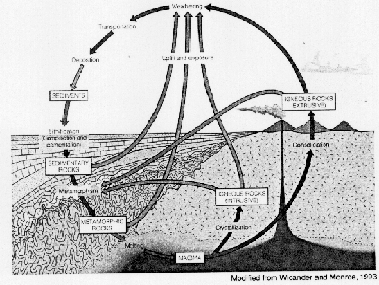
Figure 2: The rock cycle, and formation of sedimentary basins.
[Page 1-4]

Figure 3: Present-day position of tectonic plates, and the "Ring of Fire."
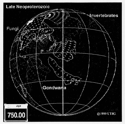
Figure 4: Plate positions near the end of the Precambrian (750 mya).
[Page 1-5]
Figure 5: Plate positions during the Middle Cambrian (510 mya).
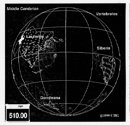
Figure 6: Plate positions during the Early Silurian (430 mya).

[Page 1-6]
Figure 7: Plate positions during the middle early Carboniferous (330 mya).
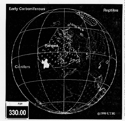
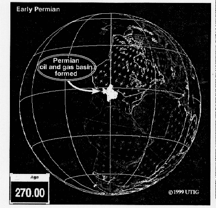
Figure 8: Plate positions during the Early Permian (270 mya).
[Page 1-7]
Figure 9: Plate positions during the Early Cretaceous (140 mya).
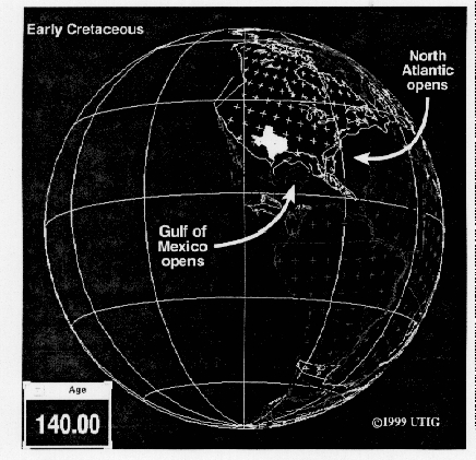
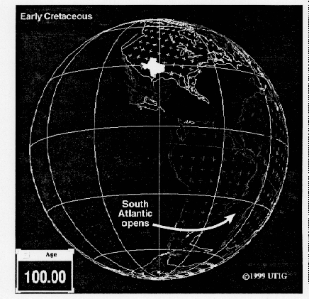
Figure 10: Plate positions during the Early Cretaceous (100 mya).
[Page 1-8]
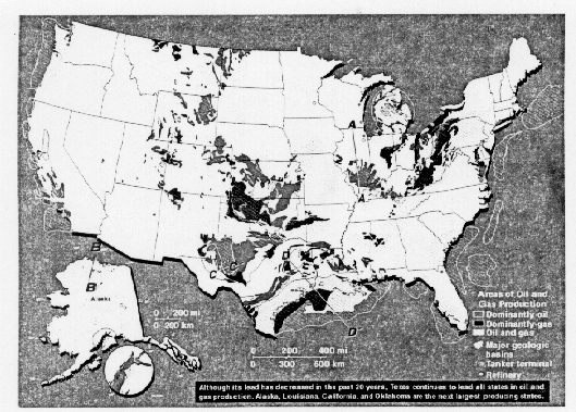
Figure 11: Major sedimentary basins that produce oil and gas in the United States.
Geologic Cross Section: Gulf Coast Basin
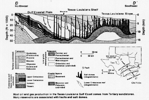
Figure 12: Geologic cross section across the Gulf of Mexico. See line D-D' on Figure 11.
[Page 1-9]
Section 2: Conditions for a Hydrocarbon Reservoir
To form an oil reservoir requires
• an oil source rock,
• the proper generation conditions,
• a migration pathway for the oil,
• a reservoir rock in which to store the oil,
• a rock to seal the oil in the reservoir,
• the proper configuration of rocks called a trap.
A source rock is commonly made up of microscopic and megascopic plants and animals that die and are deposited in lakes and oceans along with sediments. If aerobic bacteria do not eat them up, the dead plants and animals (organics) are buried and preserved. Shale and limestone are typical source rocks.
In normal heat flow settings (1.5 F/100 ft), crude oil is generated between 5,000 and 20,000 feet. Heat is assisted by overburden pressure, which causes the rocks to compact, thereby forcing the hydro-carbons out of source rocks (Figure 1). The hydrocarbons migrate along flow pathways until they are caught in a trap. A trap is a configuration of rocks that contains a reservoir and a seal and can have many different geometries (Figure 2).
A reservoir rock is a rock that contains holes, called pores, which are connected in three dimensions, called permeability (Figure 3). Pore space, called porosity, can be filled with oil, gas, or water. Permeability is the property of the rock that allows fluids or gas to flow through it. A seal is a rock not permeable to the passage of hydrocarbons, such as shale, non-permeable limestone, evaporites, and non-fractured igneous and metamorphic rocks.
One of the great challenges of petroleum geology is using what we know to predict what we do not know. For example, earth scientists study modern sedimentary environments such as rivers, deltas, and reefs (Figure 4A), and outcrops of analogous ancient rock (Figure 4B). They then attempt to understand the processes that formed the rocks so that they can create 3-D models of the geometric shapes of sedimentary deposits (Figure 4C). Geologists and geophysicists use the models as analogs to help interpret data collected from the subsurface, such as 3-D seismic or well log data (Figure 4D). In this fashion, some of the exploration risk is minimized, which is necessary because testing the interpretation with a wellbore is very expensive. This process of developing analogs is similar to case law in the legal profession.
It is a challenge not only to understand the sedimentation history but also to unravel the structural history. What were all of the forces acting on a rock to produce the complicated configuration observed today? Seismic data, including 2-D and 3-D, significantly enhance the interpretation (Figure 5).
Next: The Exploration and Production Business
[Page 1-10]
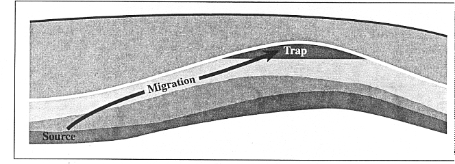
Figure 1: Forming a hydrocarbon trap.
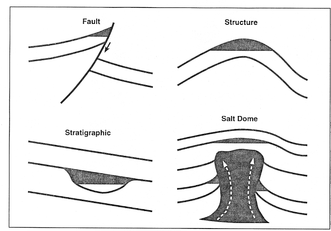
Figure 2: Cartoons illustrating a few types of hydrocarbon traps.
[Page 1-11]
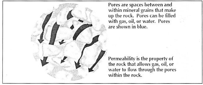
Figure 3: Porosity and permeability.
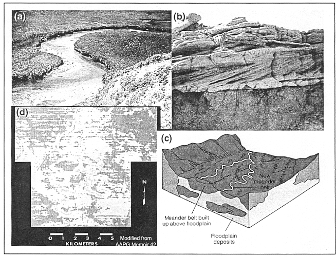
Figure 4: (a) A meandering river. (b) Outcrop of cross beds from an ancient river. (c) 3-D model sketch of a meandering river. (d) 3-D seismic showing a meandering river.
[Page 1-12]

Figure 5: Process of deforming sedimentary rocks to form an anticline structure filled with oil and gas. 2-D seismic showing an anticline filled with oil or gas.
[Page 1-13]
...
To continue reading
Request your trial