CHAPTER 3 FUNDAMENTALS OF GEOLOGY, RESERVOIR ENGINEERING, AND WELL ECONOMICS
| Jurisdiction | United States |
(Mar 1994)
FUNDAMENTALS OF GEOLOGY, RESERVOIR ENGINEERING, AND WELL ECONOMICS
San Juan Resource Area Office Bureau of Land Management
Durango, Colorado
Paul Onsager
Colorado State Office Bureau of Land Management
Lakewood, Colorado
Table of Contents
Page No.
I. Introduction
II. Geology
A. Fundamentals of Petroleum Geology
1. Some Facts to Keep in Mind
B. Stratigraphy
1. Rocks and Minerals a. Rock Typesb. Depositional Environments
C. Reservoir Quality
1. Geometry a. Detrital Formationsb. Carbonate Formations
2. Cementation Effects
D. Structure
E. Petroleum Traps and Reservoirs
1. Stratigraphic Traps
2. Structural Traps
3. Other Traps
F. Determination of Geologic Reservoir Parameters
1. Key parameters a. Porosityb. Water Saturationc. Reservoir Thicknessd. Net Hydrocarbon Porosity-Thickness
G. Derivation of Parameters
1. Core Analysis
[Page 3-ii]
2. Log Analysis a. Qualitative Log Interpretationb. Quantitative Log Analysis
H. Geologic Parameters Requisite for Drainage Cases
I. Geologic Summary
III. Reservoir Engineering
A. Fluid Migration in Petroleum Reservoirs
1. Reservoir Properties a. Porosityb. Permeabilityc. Fluid Saturationd. Relative Permeability
2. Fluid Properties a. Fluid Viscosityb. Densityc. Pressure and Temperatured. Formation Volume Factore. Fluid Compressibility
3. Fluid Flow Equation
B. Reservoir Types and Drive Mechanisms
1. Oil Reservoirs a. Solution Gas Driveb. Gas Cap Drivec. Water Drived. Gravity Drainagee. Combination Drive
2. Gas Reservoirs a. Dry Gasb. Gas Condensatec. Retrograde Condensate
3. Fluid Compressibility Considerations
C. BLM's Preliminary Engineering Review
[Page 3-iii]
1. Objectives
2. Volumetric Analysis a. Formation Volume Factorb. Recovery Factorc. Reserve Estimationd. Drainage Area Calculatione. Effect of Reservoir Parameters on Area
D. BLM's Final Engineering Review
1. Objectives
2. Geologic Data
3. Review Data and Interpretation Provided by Lessee
4. Refine Engineering Analysis
5. Drainage Factor
6. Data Sources
IV. Economic Analysis
A. Objectives
B. Discounted Cash Flow Model
C. Protective Well Model
1. Protective Well Considerations
2. Uncertainty
3. Risk
D. Discounted Cash Flow Model Inputs
1. Commodity Pricing and Revenue Stream
2. Costs
3. Discount Rates
E. Discounted Cash Flow Model Outputs
1. Measurements of Profitability
2. Profitability Determination
V. Use of "Outside Experts" versus "In-House Personnel"
VI. Summary
———————
[Page 3-1]
I. Introduction
A guiding principle of the Bureau of Land Management's (BLM) drainage protection program is the application of sound fundamental geologic and engineering principles to all potential drainage situations on Indian or federal lands. This paper will discuss the fundamentals of geology, reservoir engineering, and well economics in the drainage case context. It is intended to give the reader some background in geology, reservoir engineering, and well economics, and an understanding of the technical review process used by the BLM in resolving a drainage case.
II. Geology
A. Fundamentals of Petroleum Geology
In order to perform the reservoir engineering calculations necessary to determine the drainage area of a given well, geologic parameters must be established which describe the thickness, extent, and structure of the reservoir. This section will provide a background in the fundamentals of petroleum geology and introduce the reader to the geologic parameters necessary to calculate oil and gas drainage. Much of the following is somewhat oversimplified; however the basic concepts remain valid.
1. Some Facts to Keep in Mind...
• Fluids, including oil and gas, are contained in the pore spaces between sand grains, or in fractures and small voids; not in underground "streams", "rivers", or "pools".
• Formations below the water table are almost always totally water saturated in the absence of other fluids (i.e., oil and gas).
• Oil and gas are less dense than water and tend to float or migrate upward until they encounter a barrier.
• In an oil and gas reservoir, the pore space is partially filled with water in addition to the hydrocarbons.
• Formations were deposited, and fluids have migrated, over extremely long (in reality incomprehensible) periods of time (i.e., millions of years).
[Page 3-2]
• Sediments turn to rock through cementation/precipitation by chemically active fluids, compaction due to burial, and, to a lesser extent, heat.
B. Stratigraphy
The science of describing and classifying sedimentary rocks is called stratigraphy. Stratigraphy studies the origin and succession of rock strata including their form, distribution, composition, physical characteristics, and environment or mode of origin and deposition.
1. Rocks and Minerals
Rocks are comprised of varying amounts of different minerals. A mineral is characterized by a unique chemical composition and has specific physical properties. Rocks are classified by the relative amounts and types of minerals they contain. Quartz and calcite are the most common rock forming minerals. Quartz grains commonly form sandstones and calcite is a major constituent of limestones.
a. Rock Types
Rocks can be classified into three basic types: 1) those which formed directly from molten magma or lava called igneous, 2) those which changed in the solid state due to extreme heat and pressure called metamorphic, and 3) those which formed by accumulation of sediments or by chemical precipitation called sedimentary.
Almost all oil and gas is produced from sedimentary rocks. Sedimentary rocks include two general types: 1) Detrital or clastic, meaning derived from broken fragments; and 2) precipitates which are derived from chemical processes. Very fine-grained detrital rocks are commonly called shales, with coarser-grained rocks classified as sandstones, and very coarse-grained rocks categorized as conglomerates. Carbonates (limestones and dolomites) are the most common precipitates and are generally comprised of calcium carbonate with some amounts of very fine-grained detrital particles.
Shales are commonly the source rocks for hydrocarbons (oil and gas). Hydrocarbons are formed as organic-rich sediments are heated and compressed during burial. Generally hydrocarbons are expulsed into adjacent sandstones which are more porous and allow movement of fluids more readily than in shales. When porous rocks contain significant accumulations of hydrocarbons, they are referred to as reservoirs.
Sedimentary rocks are formed by numerous processes which transport and deposit sediments. Environments of deposition for sedimentary rocks include rivers and streams, beaches, deltas, dunes, and so on. Obviously, the mode of deposition has a strong effect on the shape and size of a deposit. Deposition generally results in the development of "layers"
[Page 3-3]
called strata. Adjacent strata having similar characteristics are grouped into units called formations. Mode of deposition controls shape, size, and "quality" of a reservoir.
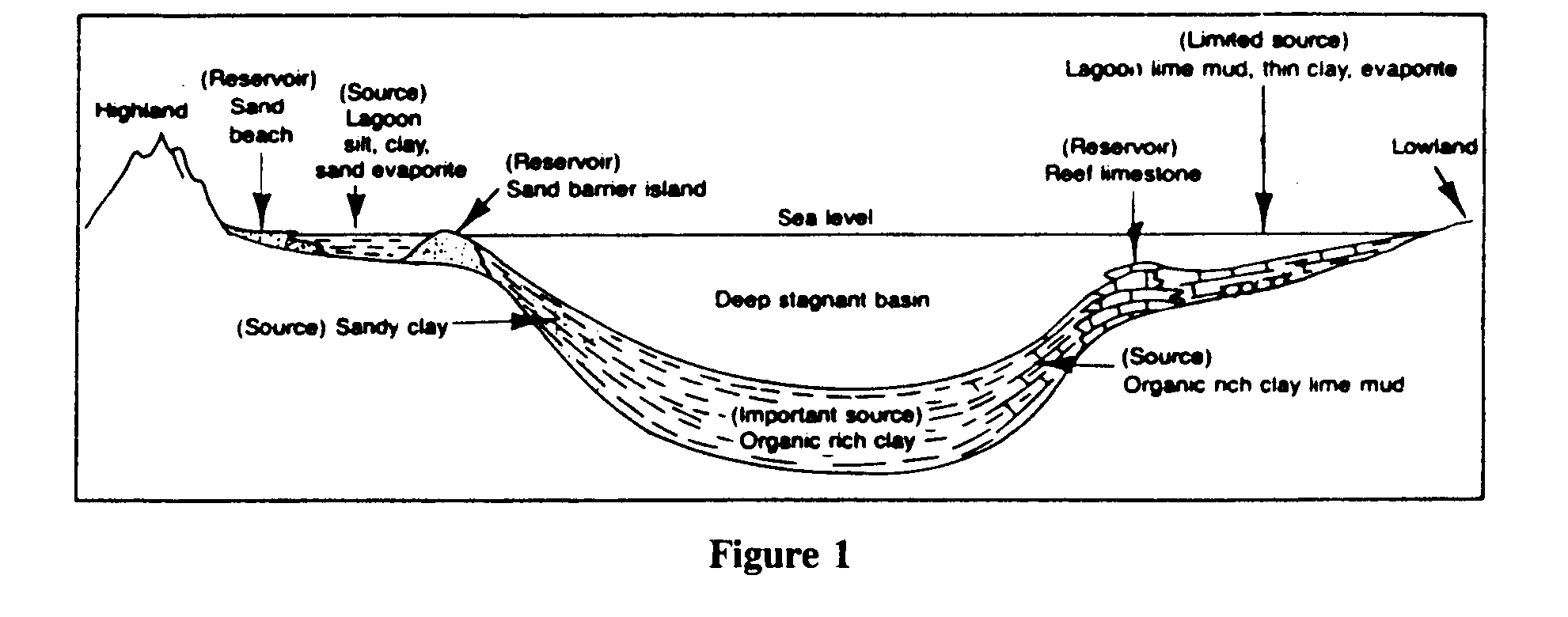
b. Depositional Environments
Environments of deposition (Figure 1) which involve detrital sediments and high energy (e.g., intense wave action associated with beaches) make excellent reservoirs. This is due to the winnowing out of fine grains, which initially choke the pore spaces, and the "sorting" of particles to a similar size which in turn maximizes pore space (porosity) and enhances connections between pore spaces (permeability). High-energy environments also cause the winnowing out of "unstable" minerals leaving "stable resistates," such as quartz, behind which are less susceptible to secondary weathering and subsequent plugging of permeability.
C. Reservoir Quality
1. Geometry
Sedimentary rocks exhibit a wide variety of geometries and thicknesses. However, when the environment of deposition is known or suspected, informed interpretation of their geometries may be deduced.
a. Detrital Formations
Detrital formations, such as sandstone and shales, vary widely in size and shape. Stream deposits are often sinuous (Figure 2) and/or lenticular (pod or lens-like). Beach deposits are often linear and elongated. Beaches and related marginal marine features often migrate seaward or landward as sea level changes over long periods of time. When this occurs, the end result is often a relatively widespread tabular deposit sometimes referred to as a "blanket" sandstone. For example, several of the producing formations in the San Juan
[Page 3-4]
Basin of northwest New Mexico typify marginal marine sandstone reservoirs. In addition to those sediments deposited by water, there are a multitude of deposits which are shaped and deposited by wind and mass movements. Formations comprised of ancient "fossilized" sand dunes, for example, may be relatively widespread such as those of the Navajo Formation of the Colorado Plateau, or they may be limited to very thin sinuous deposits, such as those in the producing Minnelusa Formation of northeast Wyoming.
b. Carbonate Formations

Carbonate formations (chemical precipitates), such as limestones, are often thick and widespread. Many are dense and lack porosity. Others have irregular voids present which store fluids, but the pores are not interconnected and lack permeability. Still others, such as those formed in a reef environment, have huge storage capacities and excellent permeabilities due to the open framework typical of reef formation. However, reefs and similar features may be confined to a relatively limited area, and wells immediately adjacent to the reef may not produce at all. When folded and/or faulted, limestones often fracture and form excellent reservoirs. Examples of this latter type of reservoir are common...
To continue reading
Request your trial