CHAPTER 2 AN INTRODUCTION TO ALASKA
| Jurisdiction | United States |
(Sep 1978)
AN INTRODUCTION TO ALASKA
Land Use Planning Commission
Anchorage, Alaska
TABLE OF CONTENTS
FORWARD
LAND ALLOCATION
Overview
The Federal Estate in Alaska
State Lands
Private Lands and the Native Land Claims Settlement
National Interest Lands-The (d)(2) Process
ALASKA LAND VALUES
Wilderness, Wildlife, and Scenic Values
Wilderness Values
Wildlife
Waterfowl and Seabirds
Unique and Endangered Bird Species
Terrestrial Mammals
Marine Mammals
Fish
Scenic Values and Landscapes
Mountains
Lakes
Glaciers and Glacial Features
Rivers
Sand Dunes
Coastal Features
Volcanos
Vegetation
Paleontological Values
Historical and Archaeological Values
Ecosystems
Energy Values
Oil and Gas
Coal
Geothermal
Hydroelectric
Uranium
Mineral Values
Minerals of National Interest (chart)
Renewable Resource Values
Timber
[Page 2-ii]
Cultivable Soils
Rangelands
Fisheries
Other Values
Natural Access Routes
Lands for Community Expansion and Habitation
References
———————
[Page 2-iii]
MAPS AND CHARTS
Title
| Alaska Is Big (same scale) | 2 |
| Climate | 4 |
| Population and Elevation | 5 |
| Land Status | 7 |
| State Lands | 9 |
| Native Entitlement | 11 |
| Birds | 23 |
| Large Mammals | 25 |
| Caribou Herd Size (chart) | 26 |
| Musk-Oxen and Caribou | 27 |
| Marine Mammals and Fish | 29 |
| Physiography | 31 |
| Glaciers | 33 |
| Major Rivers | 35 |
| Dunes, Coast, and Volcanos | 38 |
| Vegetation | 41 |
| Paleontology and History | 43 |
| Oil and Gas | 46 |
| Estimated Undiscovered Recoverable Resources for Some Alaska Basins (chart) | 47 |
| Coal and Geothermal | 50 |
| Hydroelectric | 52 |
| Metallogenic Provinces #1 | 54 |
| Metallogenic Provinces #2 | 55 |
| Mineral Potential | 58 |
| Minerals of National Interest (chart) | 59 |
| Cultivable Soils | 64 |
| Grazing and Rangelands | 68 |
| Transportation | 72 |
[Page 2-1]
FORWARD
Material in this "Introduction to Alaska" has been excerpted from the publication 'The D-2 Book,' Lands of National Interest in Alaska, prepared by the Federal-State Land Use Planning Commission for Alaska in 1977. This "D-2 Book" was prepared to present to the public and Congress, background material, a context, and recommendations regarding possible new national interest lands in Alaska—parklands, wildlife refuges, forests, and wild and scenic rivers. Therefore, besides getting a general geographical introduction to Alaska, the following pages will also introduce you to some of the elements of one of the major allocations of lands and resources in the United States for Federal, State, and private purposes.
[Page 2-2]

[Page 2-3]
LAND ALLOCATION
OVERVIEW
Alaska encompasses land and inland water areas of over 375 million acres and tide and offshore submerged lands encompassing some 37 million acres, most of which remains in its natural state. The State still has more square miles than people, and the majority of its estimated 400,000 residents are not widely diffused, as shown on the Population and Elevation map. Most live in two urban areas and the remainder live in widely scattered small villages and towns. The State's road network, while serving most of the population, extends through only a small portion of the State. Alaska's existing transportation network is shown on the Transportation map. Access to the rest of Alaska is by air or by water. Although there are producing oil and gas fields, commercial fishing, timber harvesting, and small-scale mining and farming, Alaska's natural resources are largely undeveloped.
Lands and waters whose allocation and management are yet to be determined are measured in millions of acres. They are located within the boundaries of a single state. The wildlife, wilderness, and scenic values they contain are expressed in superlatives—the highest mountains, the largest glaciers, the highest density waterfowl nesting areas. Often there is little detailed knowledge of the other resources which they may contain. Some wildlife for which these lands and waters provide habitat are of a migratory nature.
Alaska's landscape varies from a lush coastal forest to treeless Arctic tundra and complexes of mountains and icefields covering thousands of square miles. The climate ranges from brief cool summers with long daylight hours, and long dark, frigid winters in the Arctic, to southern coastal areas where temperatures fall below zero only during the deepest winter months. In Alaska's interior, temperatures ranges are extreme with prolonged periods in winter of subzero temperatures and a summer season when temperatures frequently rise to 80 or 90 degrees.
Nearly 60 percent of the State will remain in Federal ownership, most of it already designated or to be designated for particular purposes, such as national parks, wildlife refuges, forests, and national defense or petroleum reserves. Nearly 30 percent of Alaska will be owned by the State of Alaska and, except for small private landholdings obtained
[Page 2-4]
Climate Map
Omitted From Electronic Version
[Page 2-5]
Population Map
Omitted From Electronic Version
[Page 2-6]
under the public land laws or by transfer from the State of Alaska, the remaining lands will be owned in relatively large blocks by Alaska Native corporations. This land ownership pattern alone, even without other factors, dictates that the best use be made of existing management institutions and that new institutions be created to involve the major landowners and managers in cooperative comprehensive planning and management.
THE FEDERAL ESTATE IN ALASKA
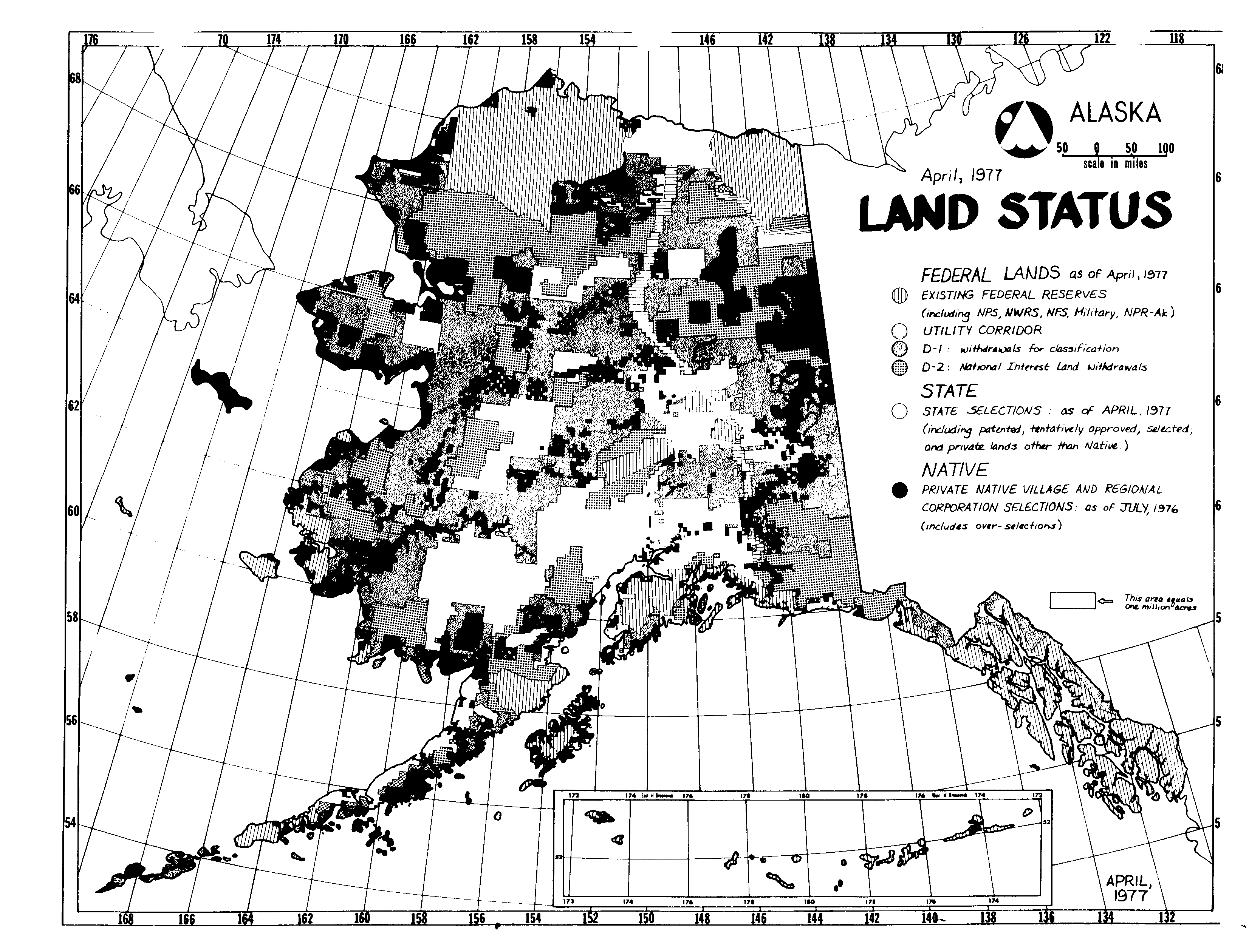
All Federal lands in Alaska either have been withdrawn as reserves for particular purposes, or are withdrawn for Native selection or for classification. Public domain lands in Alaska are currently closed to entry under most public land laws. The accompanying Land Status map shows the major land ownership as of April, 1977.
Until 1959 when Alaska became the 49th state, about 99 percent of Alaska was federally owned. Some of the Federal landholdings were administered by the U.S. Forest Service who managed the Tongass and Chugach National Forests; the Park Service who managed Mt. McKinley National Park and Glacier Bay, Katmai, and Sitka National Monuments; the U.S. Fish and Wildlife Service who managed a number of small wildlife refuges and the Kenai National Moose Range; and the military who maintained major defense installations and Naval Petroleum Reserve No. 4. Eighty percent of the Federal lands were under the jurisdiction of the Bureau of Land Management. These lands were, and are, the major part of the Nation's public domain. Since statehood, the unreserved public domain in Alaska has been reduced by the creation, in 1960, of the 9-million-acre Arctic National Wildlife Range. As the result of withdrawals from unreserved public domain lands, there are today in Alaska 11 percent (acreage) of all national forests, 25 percent of all national parks, and over 70 percent of all lands reserved for national wildlife ranges and refuges. To date there are also eight areas of about 76,000 acres designated under the Wilderness Act, with more wilderness study areas totalling 6.1 million acres awaiting congressional action.
The Federal estate in Alaska is not limited to existing reserves. Nearly 80 million acres of land has been withdrawn pursuant to Section 17(d)(2) of the Alaska Native Claims Settlement Act for possible new national parks, wildlife refuges, forests, and wild and scenic rivers. Over 103 million acres of Federal lands are currently withdrawn for classification under
[Page 2-7]
[Page 2-8]
Section 17(d)(1) of the Claims Act, including some 45 million acres in withdrawals for Native land selections, which will revert to (d)(1) status when Native selections have been finalized. Most of the Section 17(d)(1) withdrawals for classification are made under authority of the Pickett Act, which requires that the lands remain open to entry for metalliferous minerals. Withdrawal under the inherent authority of the President, on the other hand, permits the closing to mineral entry. These (d)(1) lands may, in the future, be classified for State selection or for other uses. Some of them may be designated by Congress in the same manner as those withdrawn under Section 17(d)(2). The limitation on the Secretary of the Interior to withdraw "up to 80 million acres" for study does not apply to the Congress in making its designations. With the passage of the Federal Land Policy and Management Act in 1976, it is apparent Congress intends the lands now withdrawn under Section 17(d)(1) be managed with a higher degree of environmental protection than the unreserved public domain of the past, which was subject to disposal under the public land laws. The repeal of some of these disposal laws in the Act, however, was postponed, in Alaska, for another 10 years.
STATE LANDS
In the admission of Alaska as the 49th state, Congress was confronted with how this vast territory with its small population and remoteness from the centers of trade and commerce could become a viable member of the Union. It was believed by most that the viability of such a new state must come from its natural resources. To give the new state a resource base, Congress provided in the 1958 Statehood Act that 102.5 million acres of general grant lands from the "vacant, unappropriated and unreserved" lands of Alaska could be selected by the new state within 25 years. Alaska was also entitled to University and Mental Health lands granted before statehood, to 400,000 acres from the public domain, and 400,000 acres from the national forests for community development and recreation. Alaska also gained title to submerged offshore lands to the limits of the territorial sea and submerged lands of inland navigable lakes and streams.
To date, over 72 million acres have been selected, as shown on the State Land map. The remaining entitlement must...
To continue reading
Request your trial